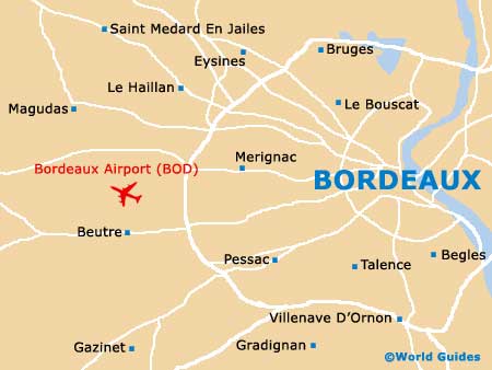
Bordeaux Merignac Airport (BOD)
City Orientation and Maps
(Bordeaux, France)
The city of Bordeaux is an impressive sight, particularly when you approach it from the southern side, next to the River. Located in the Aquitaine province of France, close to the eastern coastline, Bordeaux contains a population of more than 500,000 people and boasts a range of transport options, including a billion-Euro, modern electric tram network and the bustling Bordeaux Airport (BOD), which lies on the western outskirts.
Bordeaux's stylish tram system contrasts with the city's array of historic buildings and impressive Victorian architecture. Much of the very centre is now completely pedestrianised, meaning that many sights, shops and restaurants can be easily reached by foot. The very centre is dissected by the River Garonne, with the less developed eastern side of Bordeaux being accessible by a number of bridges, such as the Pont de Pierre.
Bordeaux Airport (BOD) Maps: Important City Districts
The main tourist information centre in Bordeaux can be found close to the Grand Théâtre, along the Cours du 30-Juilliet, where hotels can be booked and maps of the region can be purchased. Tours of the surrounding vineyards and wineries, can also be arranged here. A further tourism bureau stands in the Gironde region of Bordeaux, on the Cours de l'Intendance.
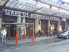
Those travelling to Bordeaux by train will arrive at the Gare St. Jean, which is located around 3 km / 2 miles to the south of the city centre and connected by regular buses and trams.
France Map

Bordeaux Map